Critical Habitat of the Nooksack Dace (Rhinichthys cataractae ssp.) Order
Version of the schedule from 2016-05-02 to 2020-07-23:


SCHEDULE(Section 2)
TABLE 1
Reaches Within the Watersheds and Riparian Reserve Strips that Constitute the Critical Habitat
| Column 1 | Column 2 | Column 3 | Column 4 | Column 5 | Column 6 | |
|---|---|---|---|---|---|---|
| Item | Watershed | Reach CodeFootnote for TABLE 1 Reaches Within the Watersheds and Riparian Reserve Strips that Constitute the Critical Habitat1 | Reach Length (m) | Reach Start Point | Reach End Point | Width of Riparian Reserve Strip of Native Vegetation on Each Bank for Entire Reach Length (m) |
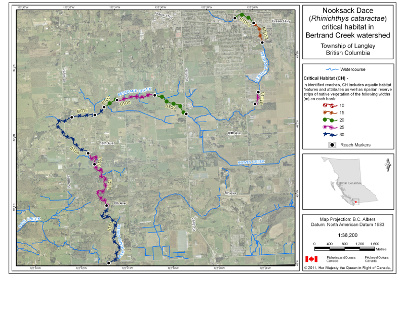
| 1 | Bertrand Creek | BTD1 | 2408 | latitude 49°00′07.96″ N, longitude 122°31′23.89″ W | latitude 49°00′57.54″ N, longitude 122°31′22.84″ W | 30 |
| 2 | Bertrand Creek | BTD2 | 1808 | latitude 49°00′57.54″ N, longitude 122°31′22.84″ W | latitude 49°01′33.71″ N, longitude 122°31′36.06″ W | 25 |
| 3 | Bertrand Creek | BTD3 | 579 | latitude 49°01′33.71″ N, longitude 122°31′36.06″ W | latitude 49°01′43.47″ N, longitude 122°31′43.65″ W | 25 |
| 4 | Bertrand Creek | BTD4 | 1844 | latitude 49°01′43.47″ N, longitude 122°31′43.79″ W | latitude 49°02′15.1″ N, longitude 122°32′02.71″ W | 30 |
| 5 | Bertrand Creek | BTD5 | 652 | latitude 49°02′15.1″ N, longitude 122°32′02.66″ W | latitude 49°02′16.13″ N, longitude 122°31′32.48″ W | 30 |
| 6 | Bertrand Creek | BTD6 | 351 | latitude 49°02′16.17″ N, longitude 122°31′32.57″ W | latitude 49°02′22.54″ N, longitude 122°31′19.8″ W | 30 |
| 7 | Bertrand Creek | BTD7 | 449 | latitude 49°02′22.54″ N, longitude 122°31′19.8″ W | latitude 49°02′28.15″ N, longitude 122°31′02.32″ W | 20 |
| 8 | Bertrand Creek | BTD8 | 1139 | latitude 49°02′28.15″ N, longitude 122°31′02.39″ W | latitude 49°02′30.62″ N, longitude 122°30′12,88″ W | 25 |
| 9 | Bertrand Creek | BTD9 | 1104 | latitude 49°02′30.64″ N, longitude 122°30′12.95″ W | latitude 49°02′13.19″ N, longitude 122°29′32.8″ W | 20 |
| 10 | Bertrand Creek | BTD13 | 356 | latitude 49°02′18.89″ N, longitude 122°28′02.9″ W | latitude 49°02′28.89″ N, longitude 122°27′57.39″ W | 25 |
| 11 | Bertrand Creek | BTD17 | 616 | latitude 49°03′11.45″ N, longitude 122°27′48.88″ W | latitude 49°03′28.69″ N, longitude 122°27′58.91″ W | 15 |
| 12 | Bertrand Creek | BTD18 | 637 | latitude 49°03′28.65″ N, longitude 122°27′59″ W | latitude 49°03′33.6″ N, longitude 122°28′23.27″ W | 20 |
| 13 | Brunette River | BRN2 | 3702 | latitude 49°14′01.47″ N, longitude 122°52′48.62″ W | latitude 49°14′52.46″ N, longitude 122°55′00.98″ W | 30 |
| 14 | Brunette River | BRN5 | 517 | latitude 49°14′27.77″ N, longitude 122°57′45.31″ W | latitude 49°14′18.66″ N, longitude 122°58′05.36″ W | 15 |
| 15 | Brunette River | BRN16 | 1615 | latitude 49°14′36.82″ N, longitude 122°56′06.59″ W | latitude 49°15′19.07″ N, longitude 122°56′34.77″ W | 15 |
| 16 | Brunette River | BRN17 | 725 | latitude 49°15′19.07″ N, longitude 122°56′34.77″ W | latitude 49°15′39.14″ N, longitude 122°56′24.4″ W | 15 |
| 17 | Brunette River | BRN20 | 2362 | latitude 49°14′49.05″ N, longitude 122°54′31.94″ W | latitude 49°15′46.53″ N, longitude 122°53′50.68″ W | 15 |
| 18 | Brunette River | BRN21 | 1052 | latitude 49°15′46.52″ N, longitude 122°53′50.66″ W | latitude 49°16′10.32″ N, longitude 122°53′26.92″ W | 10 |
| 19 | Brunette River | BRN27 | 500 | latitude 49°15′54.63″ N, longitude 122°53′53.26″ W | latitude 49°16′09.6″ N, longitude 122°53′54.38″ W | 10 |
| 20 | Brunette River | BRN33 | 665 | latitude 49°14′10.05″ N, longitude 122°56′02.82″ W | latitude 49°13′52.55″ N, longitude 122°55′54.79″ W | 10 |
| 21 | Brunette River | BRN36 | 279 | latitude 49°14′08.29″ N, longitude 122°56′03.09″ W | latitude 49°13′59.85″ N, longitude 122°56′06.6″ W | 10 |
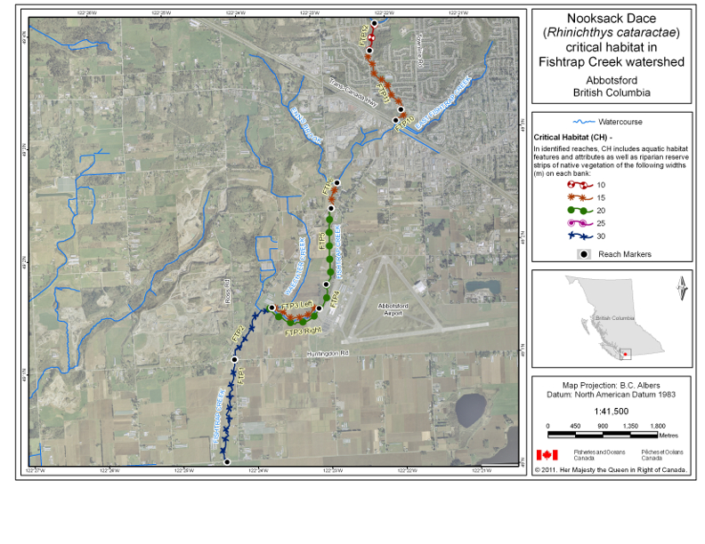
| 22 | Fishtrap Creek | FTP1 | 1984 | latitude 49°00′08.09″ N, longitude 122°24′24.82″ W | latitude 49°01′02.45″ N, longitude 49°01′02.45″ W | 30 |
| 23 | Fishtrap Creek | FTP2 | 1239 | latitude 49°01′02.63″ N, longitude 122°24′14.62″ W | latitude 49°01′29.22″ N, longitude 122°23′42.31″ W | 30 |
| 24 | Fishtrap Creek | FTP3 | 962 | latitude 49°01′29.15″ N, longitude 122°23′42.18″ W | latitude 49°01′27.53″ N, longitude 122°23′04.31″ W |
|
| 25 | Fishtrap Creek | FTP4 | 460 | latitude 49°01′27.56″ N, longitude 122°23′04.36″ W | latitude 49°01′40.21″ N, longitude 122°22′57.51″ W | 20 |
| 26 | Fishtrap Creek | FTP5 | 1300 | latitude 49°01′40.18″ N, longitude 122°22′57.51″ W | latitude 49°02′20.63″ N, longitude 122°22′50.49″ W | 20 |
| 27 | Fishtrap Creek | FTP6 | 458 | latitude 49°02′20.65″ N, longitude 122°22′50.35″ W | latitude 49°02′34.05″ N, longitude 122°22′44.6″ W | 15 |
| 28 | Fishtrap Creek | FTP10 | 282 | latitude 49°03′05.78″ N, longitude 122°21′54.74″ W | latitude 49°03′11.49″ N, longitude 122°21′50.08″ W | 15 |
| 29 | Fishtrap Creek | FTP11 | 1251 | latitude 49°03′11.49″ N, longitude 122°21′50.08″ W | latitude 49°03′43.72″ N, longitude 122°22′13.03″ W | 15 |
| 30 | Fishtrap Creek | FTP12 | 476 | latitude 49°03′43.7″ N, longitude 122°22′13.07″ W | latitude 49°03′58.17″ N, longitude 122°22′07.89″ W | 10 |
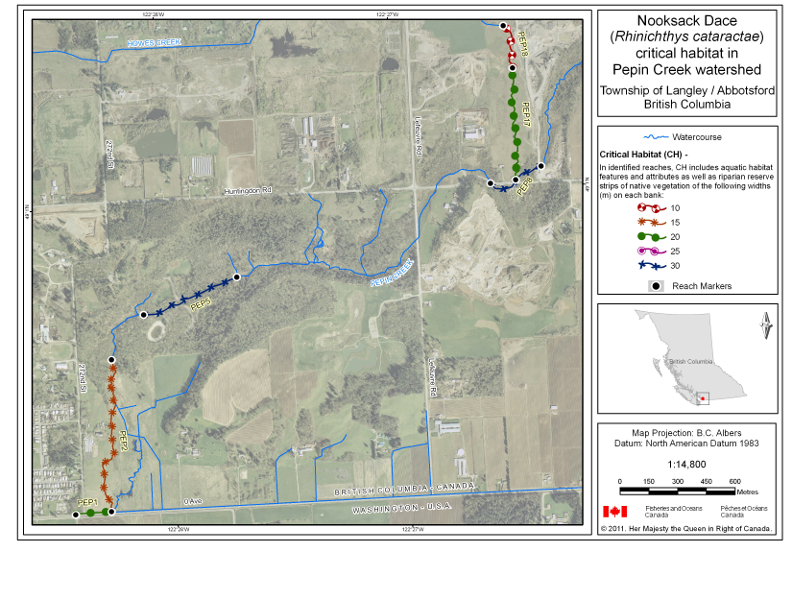
| 31 | Pepin Creek | PEP1 | 191 | latitude 49°00′08.34″ N, longitude 122°28′26.11″ W | latitude 49°00′08.57″ N, longitude 122°28′16.9″ W | 20 |
| 32 | Pepin Creek | PEP2 | 926 | latitude 49°00′08.57″ N, longitude 122°28′16.9″ W | latitude 49°00′34.25″ N, longitude 122°28′14.93″ W | 15 |
| 33 | Pepin Creek | PEP5 | 540 | latitude 49°00′41.61″ N, longitude 122°28′06.16″ W | latitude 49°00′47.19″ N, longitude 122°27′41.86″ W | 30 |
| 34 | Pepin Creek | PEP8 | 326 | latitude 49°01′00.9″ N, longitude 122°26′35.68″ W | latitude 49°01′03.37″ N, longitude 122°26′22.49″ W | 30 |
| 35 | Pepin Creek | PEP17 | 669 | latitude 49°01′01.29″ N, longitude 122°26′29.16″ W | latitude 49°01′20.22″ N, longitude 122°26′28.5″ W | 20 |
| 36 | Pepin Creek | PEP18 | 263 | latitude 49°01′20.22″ N, longitude 122°26′28.5″ W | latitude 49°01′27.43″ N, longitude 122°26′30.39″ W | 10 |
Return to footnote 1See maps.
Maps
Map 1: Critical Habitat — Bertrand Creek Watershed

Map 2: Critical Habitat — Brunette River Watershed

Map 3: Critical Habitat — Fishtrap Creek Watershed

Map 4: Critical Habitat — Pepin Creek Watershed

TABLE 2
Key Features and Attributes of the Critical Habitat
| Column 1 | Column 2 | Column 3 | Column 4 | Column 5 | |
|---|---|---|---|---|---|
| Item | Geographic Location | Life Stage | Function | Features | Attributes |
| 1 | Reaches within Bertrand Creek, Brunette River, Fishtrap Creek and Pepin Creek watersheds | Adult and juvenile | Spawning, nursery, rearing and feeding | Riparian habitat |
|
| 2 | Reaches within Bertrand Creek, Brunette River, Fishtrap Creek and Pepin Creek watersheds | Adult | Spawning (April – July) | Riffle habitat |
|
| 3 | Reaches within Bertrand Creek, Brunette River, Fishtrap Creek and Pepin Creek watersheds | Juvenile | Nursery and rearing | Shallow pool habitat |
|
| 4 | Reaches within Bertrand Creek, Brunette River, Fishtrap Creek and Pepin Creek watersheds | Juvenile | Feeding | Shallow pool habitat |
|
| Adult and juvenile | Riffle habitat |
|
- Date modified: