
Tang.ɢ wan — ḥačxʷiqak — Tsig is Marine Protected Area Regulations (SOR/2024-122)
Full Document:
- HTMLFull Document: Tang.
ɢ wan — ḥačxʷiqak — Tsig is Marine Protected Area Regulations (Accessibility Buttons available) | - XMLFull Document: Tang.
ɢ wan — ḥačxʷiqak — Tsig is Marine Protected Area Regulations [29 KB] | - PDFFull Document: Tang.
ɢ wan — ḥačxʷiqak — Tsig is Marine Protected Area Regulations [654 KB]
Regulations are current to 2026-05-26
Table of Contents
Tang.ɢ wan — ḥačxʷiqak — Tsig is Marine Protected Area Regulations
SOR/2024-122
Registration 2024-06-10
Tang.
P.C. 2024-655 2024-06-10
Her Excellency the Governor General in Council, on the recommendation of the Minister of Fisheries and Oceans, makes the annexed Tang.ɢwan — ḥačxʷiqak — Tsigis Marine Protected Area Regulations under subsection 35(3)Footnote a of the Oceans ActFootnote b.
Return to footnote aS.C. 2019, c. 8, s. 4(3)
Return to footnote bS.C. 1996, c. 31
Interpretation
Marginal note:Definition of Marine Protected Area
1 (1) In these Regulations, Marine Protected Area means the area of the sea that is designated by section 2.
Marginal note:Geographical coordinates
(2) In the schedule, all geographical coordinates (latitude and longitude) are expressed in the North American Datum 1983, Canadian Spatial Reference System (NAD83, CSRS).
Marginal note:Geographical coordinates for points
(3) The geographical coordinates of the points referred to in sections 2 and 3 are set out in the schedule.
Designation
Marginal note:Marine Protected Area
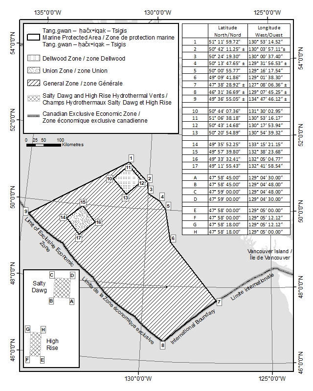
2 (1) The area of the sea depicted in the schedule that is bounded by the following lines is designated as the Tang.ɢwan — ḥačxʷiqak — Tsigis Marine Protected Area:
(a) a rhumb line drawn from point 1 to point 2, with point 2 being located on the western boundary of the Scott Islands Protected Marine Area, as described in Schedule 1 to the Scott Islands Protected Marine Area Establishment Order;
(b) a rhumb line drawn southerly following the western boundary of the Scott Islands Protected Marine Area, as described in Schedule 1 to the Scott Islands Protected Marine Area Establishment Order, to point 3;
(c) a rhumb line southeasterly following the boundary of the Scott Islands Protected Marine Area, as described in Schedule 1 to the Scott Islands Protected Marine Area Establishment Order, to point 4;
(d) a series of rhumb lines drawn from point 4 to point 5 and then to point 6;
(e) a rhumb line to a point on the international boundary between Canada and the United States intersecting a rhumb line drawn from point 6 to point 7;
(f) a line southwesterly following the international boundary between Canada and the United States to point 8, on the seaward limit of the exclusive economic zone of Canada; and
(g) a line northwesterly following the seaward limit of the exclusive economic zone of Canada to a point intersecting a rhumb line drawn from point 1 to point 9, and then a rhumb line back to point 1.
Marginal note:Seabed, subsoil and water column
(2) The Marine Protected Area consists of the seabed, the subsoil to a depth of 1 000 m and the water column above the seabed.
Management Zones
Marginal note:Boundaries
3 The Marine Protected Area consists of the following management zones, each of which is depicted in the schedule:
(a) the Dellwood Zone, which consists of the seabed, the subsoil to a depth of 1 000 m and the water column above the seabed and is bounded by a series of rhumb lines drawn from points 10 to 13 and then back to point 10;
(b) the Union Zone, which consists of the seabed, the subsoil to a depth of 1 000 m and the water column above the seabed and is bounded by a series of rhumb lines drawn from points 14 to 17 and then back to point 14; and
(c) the General Zone, which consists of the seabed, the subsoil to a depth of 1 000 m and the water column above the seabed that is within the part of the Marine Protected Area that is not within the Dellwood Zone or the Union Zone.
Prohibited Activities
Marginal note:Prohibition
4 It is prohibited to carry out any activity in the Marine Protected Area that disturbs, damages, destroys or removes from the Marine Protected Area any living marine organism or any part of its habitat or that is likely to do so.
Exceptions
Marginal note:Permitted activities
5 Despite section 4, the following activities may be carried out in the Marine Protected Area:
(a) the following fishing activities when conducted in accordance with the Fisheries Act, the Coastal Fisheries Protection Act and the regulations to those Acts:
(i) fishing, other than commercial fishing, that is authorized under the Aboriginal Communal Fishing Licences Regulations and that does not involve the use of fishing gear that contacts the seabed, such as bottom trawls, dredges, traps or bottom longlines;
(ii) commercial or recreational fishing in the General Zone carried out by means of a pelagic hook and line or a midwater trawl that does not involve the use of that fishing gear at a depth greater than 500 m below the sea surface, and
(iii) commercial or recreational fishing in the Dellwood Zone or the Union Zone that is carried out by means of a pelagic hook and line that does not involve the use of that fishing gear at a depth greater than 100 m below the sea surface;
(b) the laying, maintenance or repair of cables;
(c) the navigation of a vessel;
(d) an activity that is carried out for the purpose of public safety, national defence, national security or law enforcement or to respond to an emergency; and
(e) an activity that is part of an activity plan that has been approved by the Minister.
Activity Plan
Marginal note:Submission to Minister
6 A person who proposes to carry out a scientific research or monitoring activity or an educational activity in the Marine Protected Area must submit to the Minister an activity plan that contains the following information:
(a) the person’s name, address, telephone number and email address;
(b) if the activity plan is submitted by an institution or organization, the name of the individual who will be responsible for the proposed activity and their title, address, telephone number and email address;
(c) the name of each vessel that the person proposes to use to carry out the activity, its state of registration and registration number, its radio call sign and the name, address, telephone number and email address of its owner, master and any operator;
(d) a detailed description of the proposed activity and its purpose, the methods or techniques that are to be used to carry out the activity and the data to be collected;
(e) the geographical coordinates of the site of the proposed activity and a map that shows the location of the activity within the Marine Protected Area;
(f) the proposed dates and alternative dates on which the proposed activity is to be carried out;
(g) a list of the equipment that is to be used, the means by which it will be deployed and retrieved and the methods by which it is to be anchored or moored;
(h) a list of the types and quantities of samples that are to be collected;
(i) a list of any substances that may be deposited during the proposed activity in the Marine Protected Area — other than substances that are authorized under the Canada Shipping Act, 2001 to be deposited in the navigation of a vessel — and the quantity and concentration of each substance;
(j) a description of the adverse environmental effects that are likely to result from carrying out the proposed activity and of any measures that are to be taken to monitor, avoid, minimize or mitigate those effects;
(k) a description of any scientific research or monitoring activity or educational activity that the person has carried out or anticipates carrying out in the Marine Protected Area; and
(l) a general description of any study, report or other work that is anticipated to result from the proposed activity and its anticipated date of completion.
Marginal note:Approval
7 (1) The Minister must approve an activity plan if
(a) the scientific research or monitoring activities set out in the plan are not likely to destroy the habitat of any living marine organism in the Marine Protected Area and
(i) will serve to increase knowledge of the habitat of any living marine organism in the Marine Protected Area or the ecosystems these habitats support in the Marine Protected Area, or
(ii) will serve to assist in the management of the Marine Protected Area; and
(b) the educational activities set in out in the plan
(i) are not likely to damage, destroy or remove from the Marine Protected Area any living marine organism or any part of its habitat, and
(ii) will serve to increase public awareness of the Marine Protected Area; or
(c) the approval of the activity plan is necessary to be consistent with the United Nations Convention on the Law of the Sea, signed by Canada on December 10, 1982 or customary international law.
Marginal note:Approval prohibited
(2) However, the Minister must not approve an activity plan under paragraph 1(a) or (b) if
(a) the scientific research or monitoring activities set out in the plan are likely to adversely affect the ecological integrity of
(i) the Salty Dawg hydrothermal vent, being the area of the sea depicted in the schedule that is bounded by a series of rhumb lines drawn from points A to D and then back to point A, or
(ii) the High Rise hydrothermal vent, being the area of the sea depicted in the schedule that is bounded by a series of rhumb lines drawn from point E to H and then back to point E;
(b) any substance that may be deposited during the proposed activity is a deleterious substance as defined in subsection 34(1) of the Fisheries Act, unless the deposit of the substance is authorized under subsection 36(4) of that Act; or
(c) the cumulative environmental effects of the proposed activity, in combination with those of any other past and current activities carried out in the Marine Protected Area, are such that the activity is likely to
(i) destroy the habitat of any living marine organism in the Marine Protected Area, or
(ii) adversely affect the biological, chemical or oceanographic processes that maintain or enhance the biodiversity, structural habitat or ecosystem function in the Marine Protected Area.
Marginal note:Timeline for approval
(3) The Minister’s decision in respect of an activity plan must be made within
(a) 90 days after the day on which the plan is received; or
(b) if amendments to the plan are made, 90 days after the day on which the amended plan is received.
Marginal note:Activity report
8 (1) If the Minister approves an activity plan, the person who submitted it must provide the Minister with an activity report within 90 days after the last day of the activity and the report must contain
(a) the data collected during the activity;
(b) the type and quantity of any sample that was collected, the date of collection and the geographic coordinates of the sampling site;
(c) an evaluation of the effectiveness of any measures taken to monitor, avoid, minimize or mitigate the adverse environmental effects of the activity; and
(d) a description of any event that occurred during the activity and that was not anticipated in the activity plan, if the event could result in the disturbance, damage, destruction or removal from the Marine Protected Area of any living marine organism or any part of its habitat.
Marginal note:Studies, reports or other publications
(2) The person must also provide the Minister with a copy of any study, report or other publication that results from the activity and is related to the conservation and protection of the Marine Protected Area. The study, report or other publication must be provided within 90 days after the day on which it is published.
Repeal
9 The Endeavour Hydrothermal Vents Marine Protected Area RegulationsFootnote 1 are repealed.
Return to footnote 1SOR/2003-87
Coming into Force
Marginal note:Registration
10 These Regulations come into force on the day on which they are registered.
SCHEDULE/ANNEXE(Subsections 1(2) and (3) and 2(1), section 3, subparagraphs 7(2)(a)(i) and (ii)/paragraphes 1(2) et (3) et 2(1), article 3 et sous-alinéas 7(2)(a)(i) et (ii))Tang.ɢwan — ḥačxʷiqak — Tsigis Marine Protected Area/Zone de protection marine Tang.ɢwan — ḥačxʷiqak — Tsigis
Page Details
- Date modified: